

Alan Arbogast and Kevin McKeehan Participate in Multi-Phased Research to Understand Michigan’s Dynamic Coastal Dunes
June 2, 2020
In conjunction with the Michigan Environmental Council, the Department of Geography, Environment, and Spatial Sciences, and the Department of Community Sustainability at Michigan State University recently concluded a phase of ongoing research focused on Michigan’s coastal dunes. This project is the result of a partnership between the state of Michigan, its Department of Environment, Great Lakes, and Energy (EGLE), the Michigan Environmental Council, Michigan State University, and citizen scientists across the state. It is funded by the Coastal Management Program of Michigan’s Department of Environment, Great Lakes, and Energy, which in turn is supported by a U.S. Department of Commerce grant.
Learning to Live in Dynamic Dunes: Citizen Science and Participatory Modeling in the Service of Michigan Coastal Dune Decision-Making is the latest phase of a multi-year endeavor to gain a better understanding of Michigan’s coastal dune landscapes and how citizens understand and perceive these complex systems. The knowledge gained in this project will prove critical to the long-term management and preservation of a true global treasure—the most extensive collection of freshwater coastal dunes found anywhere in the world.
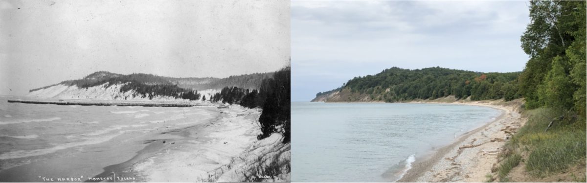
Photo Credit – 1905, National Park Service; 2019, Kevin McKeehan, Michigan State University.
The project is part of an ongoing effort to advance the collective awareness and understanding of Michigan’s coastal dunes. The first effort, also funded by the Coastal Management Program, began in 2014 with the project, Bringing the Latest Science to the Management of Michigan’s Coastal Dunes. This work, in turn, was followed by a project launched in late 2016, entitled Valuing Michigan’s Coastal Dunes: GIS Information and Economic Data to Support Management Partnerships. Collectively these projects have expanded our historical understanding of dune management, enhanced dune mapping resources, and estimated the value of coastal dunes based on the citizen’s recreational use.
Based on the results and discussions from these earlier projects, this current effort began in late 2018. Core researchers included Alan Arbogast, Professor and Chair of the Department of Geography, Robert Richardson, Professor and Associate Chair of the Department of Community Sustainability, and Tom Zimnicki, Program Director for Groundwater, Surface Water, and Agriculture at the Michigan Environmental Council. In addition, Kevin McKeehan, MSU Ph.D. candidate in Geography, contributed to the project by mapping recent changes to Michigan’s coastal dunes through a practice known as repeat photography.
To learn more about this exciting and vital work, visit https://bit.ly/3dmxgMk.