THE SNOWBELTS
Snowfall results from both passing cyclonic storms and lake-effect clouds, but the snow
that falls in most of the eastern half of the Lower Peninsula and the southern third of
the Upper Peninsula is primarily cyclonic and indicates what would generally prevail
across the state if there were no lake-effect. In other words, the relatively low annual
snowfall of 50 to 60 inches in the northeastern Lower Peninsula and southern Upper
Peninsula would be typical of all the northern areas if Lakes Superior and Michigan did
not contribute to local snowfall. Thus, the annual total of 180 inches on the Keweenaw
Peninsula, the highest average statewide may be as much as two-thirds lake-effect snow,
and the snowfall in Otsego and Antrim Counties in the Lower Peninsula may be at least 50
percent lake-effect.
The greatest seasonal snowfall totals are found in northern lee-shore
areas over higher terrain-the so-called snow-belt regions. The contribution of the
lake-effect to total annual snowfall decreases southward through the western Lower
Peninsula until it contributes less than half of the total in Berrien and Van Buren
Counties. The annual snowfall decreases southward through all the Lower Peninsula because
the percentage of winter precipitation that falls as rain is greater in the southern
counties. Lake-effect snow also falls less often in the snow belt of the southwestern
Lower Peninsula than in the north because there are fewer days when the atmosphere is
sufficiently colder than the water of Lake Michigan to generate the lake-effect.
Climatic "lake effects" stem from the
water surface that the lakes expose to the atmosphere and from the contrasting physical
properties of land and water. The lake-vs-land contrasts can result in pronounced surface
temperature gradients at shorelines. The most widely known climatic influence of the Great
Lakes involves lake effect snowfall. However, the lakes influence many other aspects of
climate, including air temperature, summer precipitation, cloud cover, and local winds.
As cold arctic air masses sweep over the lakes, they warm from below
and become saturated. The unstable, saturated air rises and may produce heavy showers of
"lake effect snow". As this air moves over the lee shores of the lakes,
additional lifting is provided by low hills and by convergence as the air slows down over
the rougher terrain. Lake effect snowfall can account for 30% to 60% of the total snowfall
at some locations immediately to the lee of the lakes.
The map below shows average snowfall for the Great Lakes region, for
the years 1951-1980. The major lake effect snowbelts are clearly shown by the darker
shaded areas. The data illustrate that these lake effect belts are primarily located east
or south of the Great Lakes.
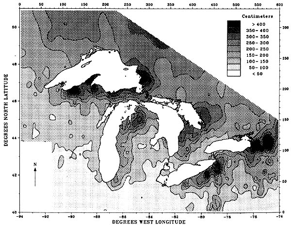
Source: Norton, D.C. and S.J. Bolsenga. 1993. Spatiotemporal trends in lake effect and continental snowfall in the Laurentian Great Lakes, 1951-1980. J. Climate 6:1943-1956.
One of the major mechanisms whereby air is lifted, and lake effect precipitation is formed, is called "convergence uplift". This type of lifting occurs as air moving across the smooth water body (lake) encounters the rougher land mass. The air then "piles up" on the lee shore zone, and is forced to rise. This rising action sparks much of the lake effect snow near the lee shores of the Great Lakes. The diagram below shows how convergence uplift occurs, and also illustrates that the opposite situation on the windward shores (e.g., Wisconsin) inhibits lake effect snow there.
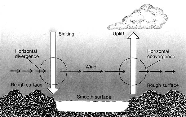
Source: Unknown
Parts of the text on this page have been modified from L.M. Sommers' book entitled, "Michigan: A Geography".
This material has been compiled for educational use only, and may not be reproduced without permission. One copy may be printed for personal use. Please contact Randall Schaetzl (soils@msu.edu) for more information or permissions.