In the years after 1776, Michigan was part
of the region known as the "Old Northwest". The British maintained forts in the
Northwest until the 1790s, and briefly retook much of the region in the War of 1812.
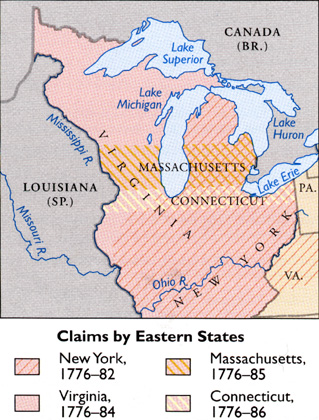
During the same period, four eastern states--Virginia, New York, Massachusetts, and
Connecticut--had overlapping claims in the region.
Source: Atlas of Michigan, ed.
Lawrence M. Sommers, 1977.
These claims were, fortunately, gradually ceded to the federal government. In 1784,
then-congressman Thomas Jefferson (below) proposed dividing this land, the "Old
Northwest", into 10 states.
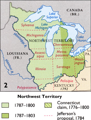
Source: Atlas of Michigan, ed.
Lawrence M. Sommers, 1977.
Congress issued the now-famous Land Ordinance of 1785 that
directed how this area should be surveyed for land sales and settlement. In 1787, it
issued the Northwest Ordinance, authored by Nathan Dane, establishing the Northwest
Territory. This Ordinance established the "Old Northwest" from land that
had been ceded to the fledgling United States from Britain, after the Revolutionary War.
This land was to be slave-free (though some slavery did go on), and cut up into not less
than three nor more than five states. As such, it came to be known as the
"Northwest Territories". That ordinance also established a bill of rights
and enabled any part of the territory with at least 60,000 citizens to ask for full
statehood.
Thomas Jefferson, arguably one of the most intelligent and wise men in our nation's
history, is credited with drafting not only the Constitution, but also the Land Ordinance
of 1785. The maps below show the various stages that the Northwest Territories took,
on the road to the creation of five states out of this tract of land.
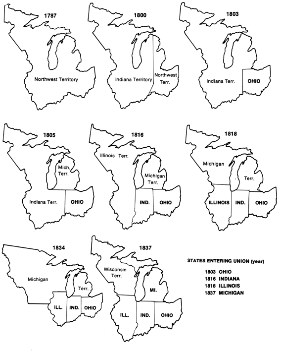
Source: Unknown
The first state to be carved out of the Northwest Territory was Ohio in 1803. Most of the rest of the area had already been reorganized as Indiana Territory. For greater ease in administration. Congress later organized the Illinois and Michigan territories. Territorial boundaries were drawn in Washington, with little consideration for the people living in the region. All of the future Michigan was, remember, still under the sovereignty of Native American nations. These nations gave (ceded) some lands near Detroit to French-Canadian settlers, who divided the lands into French-style "long lots". Special commissioners later recorded these early land holdings for the U.S. government.
Michigan Territory. In 1818, after both Illinois and Indiana had become states,
left-over parts of their territories were joined to Michigan Territory. The territorial
capital was in Detroit, which was too far away for people living on the western side of
Lake Michigan. Their numbers swelled in the 1820s because of the "lead rush"
(lead had been discovered and was being mined in Wisconsin), and improved access from the
East Coast to the Great Lakes via the Erie Canal.
Michigan Territory settlers wanted the Illinois state border fixed at
the southern tip of Lake Michigan, so they could control Chicago and all of the Lead
District, and objected when the border was fixed 61 miles to the north. In 1824, Federal
Judge James Doty proposed that this region join the rest of Michigan Territory (after the
anticipated statehood for the Lower Peninsula) to form a new "Chippewau
Territory." But instead, in 1834, Michigan’s territorial boundaries were
extended west to the Missouri River--far beyond the original Northwest. When Michigan
finally became a state in 1837, it consisted of both the Lower Peninsula and Upper
Peninsula, and had given up its claim over Toledo.
This material has been compiled for educational use only, and may not be reproduced without permission. One copy may be printed for personal use. Please contact Randall Schaetzl (soils@msu.edu) for more information or permissions.