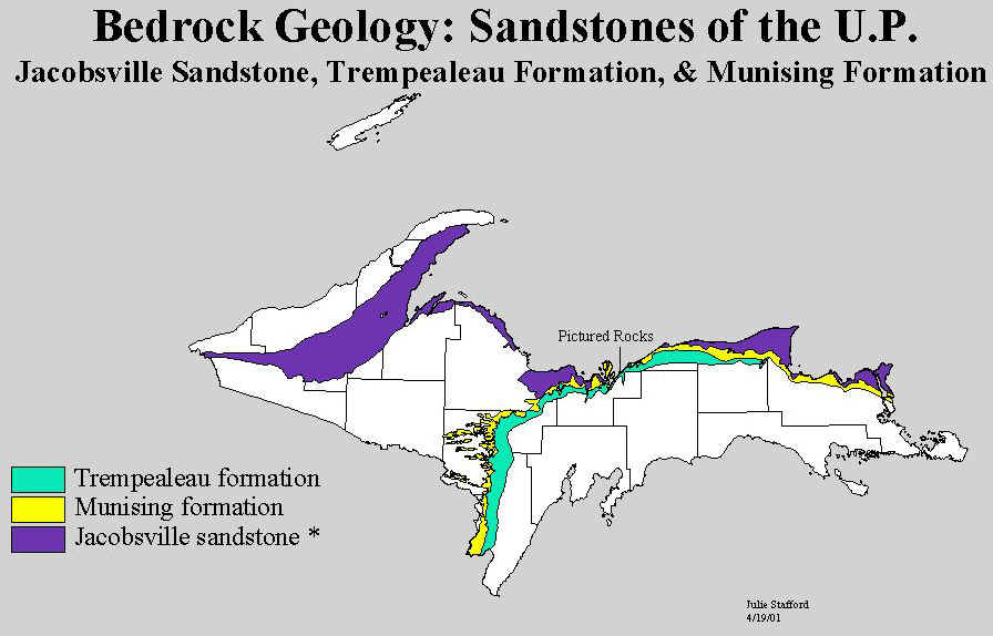
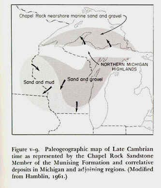
The first of Paleozoic seas, during the Cambrian period, received coarse sandy sediments from swift streams flowing southward from bare highlands to the north. The shore line was somewhere in the Lake Superior trough, and to the west, somewhere near the central part of Keweenaw County. The rocks representing Cambrian time are mainly sandstones, and cover large parts of the UP (see map below).
Source: Michigan State University, Department of Geography
As much of the sediment was derived from the iron formations in the west they range in
color from a deep dark red to mottled red and white, buff, white, and gray. Towards the
end of Cambrian time the sediments became finer, the sea shallower, and its shore farther
south; the sediments were clear white sand.
The Cambrian sandstones were, thus, the first rocks laid
down on the Precambrian basement.
Hamblin, W.K. 1961.
Paleogeographic evolution of the Lake Superior region from Late Keweenawan
to Late Cambrian time. Geol. Soc. Am. Bull. 72:1-18.
They are important reservoirs of groundwater in the Northern and Southern Peninsulas. The
red Jacobsville Sandstone, a good building stone, was formerly quarried at Jacobsville and
used for building purposes until shipping costs and cheaper cement-concrete materials made
production costs prohibitive. Michigan has large reserves of sandstone in the Peninsula.
Near the top of the AuTrain formation the sandstone is free enough of impurities to make
it a potential source of glass sand. At present probably the tourist receives greatest
value from the sandstone in viewing the scenic effects produced by weathering along
exposed edges at the lake shore, and in the little gorges cut back into the cliffs by
rivers--Pictured Rocks, Miner’s Castle, Miner’s Falls, and many others.
The Ordovician-St. Peters sandstone is also a good water reservoir (aquifer).
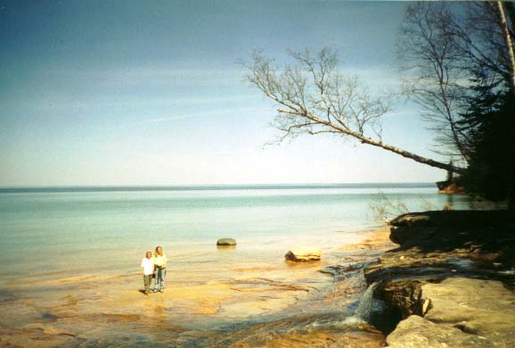
The Cambrian sandstones near Picture Rocks National Lakeshore.
Source: Michigan State University, Department of Geography,
used with permission.
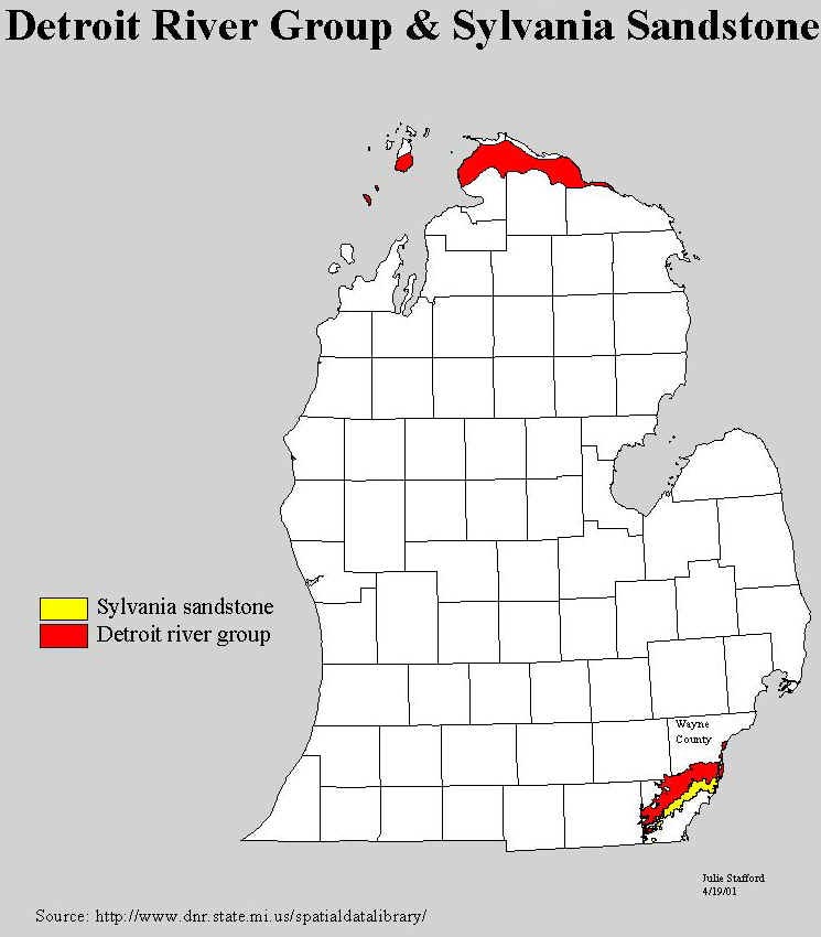
The fossils suggest that the climate again became genial at the close of the Silurian, the seas warm, and the sea creatures returned to the region. Silurian time totaled 25 million years.
The climate changed to warm and moist in the Devonian period, which was to last 35
million years. Michigan was almost an enclosed pool of the Devonian sea and the northern
shore of the sea was somewhere in Lake Michigan across the St. Ignace Peninsula into
northern Lake Huron basins. A part of the southeastern shore cut diagonally across Monroe
County from northeast to southwest. On the southeastern shore sand dunes were whipped up
by the Devonian winds and are now beds of white sandstone --- the Sylvania. Spreading deep
into the basin from the southeast, layers of sand and lime and salt were deposited which
became the formation we know term the Detroit River formation.
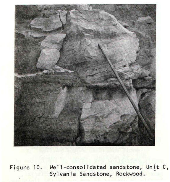
The Sylvania Sandstone
Devonian rocks supply a variety of mineral resources. A
Devonian sandstone formation known as the Sylvania Sandstone located at or near the
surface in Wayne and Monroe counties contains high silica, uncontaminated sand grains.
Source:
Michigan State University, Department of Geography
Mining sandstone involves different techniques (i.e., blasting, crushing, etc.) and the
process is more expensive. However, the requirements of the glassmaking industry for
high-silica sand with negligible contaminants motivate the operators to mine the
sandstone, even at great expense.
Source:
Unknown
From the outcrop of the basal Sylvania sandstone in Wayne and Monroe
counties we obtain sand used in the manufacture of glass. Some of this sand is so free
from iron, the most vexing impurity, that the sand is suitable for optical glass. During
and shortly after World War I most of the glass used for the manufacture of optical glass
for the federal government was obtained from the Michigan quarries. The sand is now used
for the manufacture of plate glass, fine table glassware, and common glassware of many
uses. These sandstone beds are believed to be ancient dunes blown up on the shore of an
ancient Devonian sea. As we trace the Sylvania towards the center of the Michigan Basin,
we find from the logs (records) of wells drilled into it that it becomes thicker with
lenses of limestone and shale, and that the porous parts of the formation contain brines.
These brines are in use as brine reserves for chemical industries, and also possible oil
and gas reserves.
At its close the Devonian seas became shallow and were bordered by
low-lying lands from which sluggish rivers brought sediments black with decayed
vegetation. Gradually the time changed to the Mississippian --- the first part of the
Carboniferous Period, or the Coal Age. For 35 million years the Mississippian sea
alternately entered and partially retreated from the bay which covered most of the
Southern Peninsula. Note that now the water in the Michigan basin is better described as a
bay, not a sea–it is shallower and warmer. The condition of the lands about our
"Michigan bay" varied so that a variety of sediments were deposited; nor were
the sediments the same in all parts of the basin: we have incomplete bowls. Thick shales
--- black Antrim, green Ellsworth, blue Coldwater --- underlie the Marshall sandstone,
which in turn is overlain by the Michigan shales, sandstones, limestones, and the thick
gypsum beds which indicate an arid climate and chemical precipitation. Near the end of
Mississippian time the Bayport limestone sediments were deposited. Thus, the Mississippian
is characterized by varying depositional environments, but all were shallow-water
sediments of mud and sand. The stratigraphic column below should make all these rock
strata more clear in your mind.
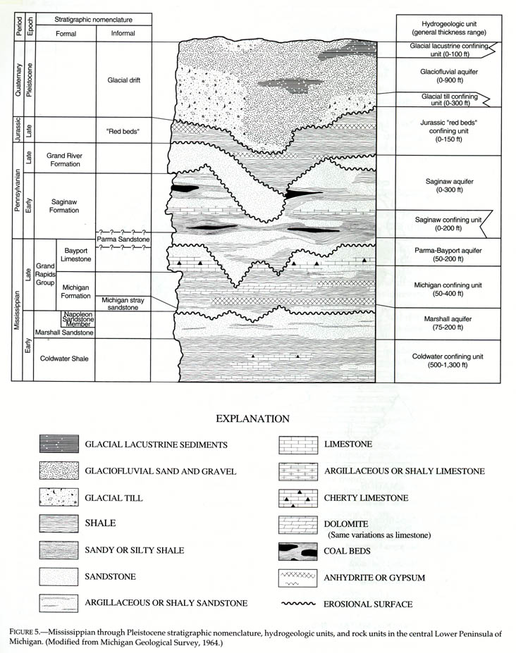
Source: C.M. Davis, Readings in the Geography
of Michigan (1964).
Water within the Marshall sandstone is fresh at the edges of the Michigan Basin, and here
the rock unit is a very good freshwater aquifer. The rim of the Marshall sandstone
comes to, or is near, the surface in many places from the tip of the Thumb where it is
carved to interesting scenery, through Huron, Jackson, Calhoun, and Ottawa counties. In
the early day many quarries were opened in it and the sandstone used for building
purposes. One of our ghost towns is
Grindstone City, Huron
County, where once a flourishing industry produced the largest and finest grindstones, scythestones, and honestones in the world. Artificial carborundum, however, killed that
industry. But when particularly fine grind-and hone-stones were needed the quarry was
occasionally operated. The map below shows where the Marshall sandstone is the
uppermost bedrock unit.
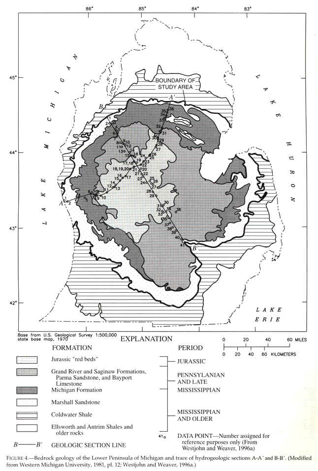
Source: C.M. Davis, Readings in the Geography
of Michigan (1964).
In the center of the basin, however, the sandstone contains very saline
water--6 times as salty as the ocean! The map below illustrates this point.
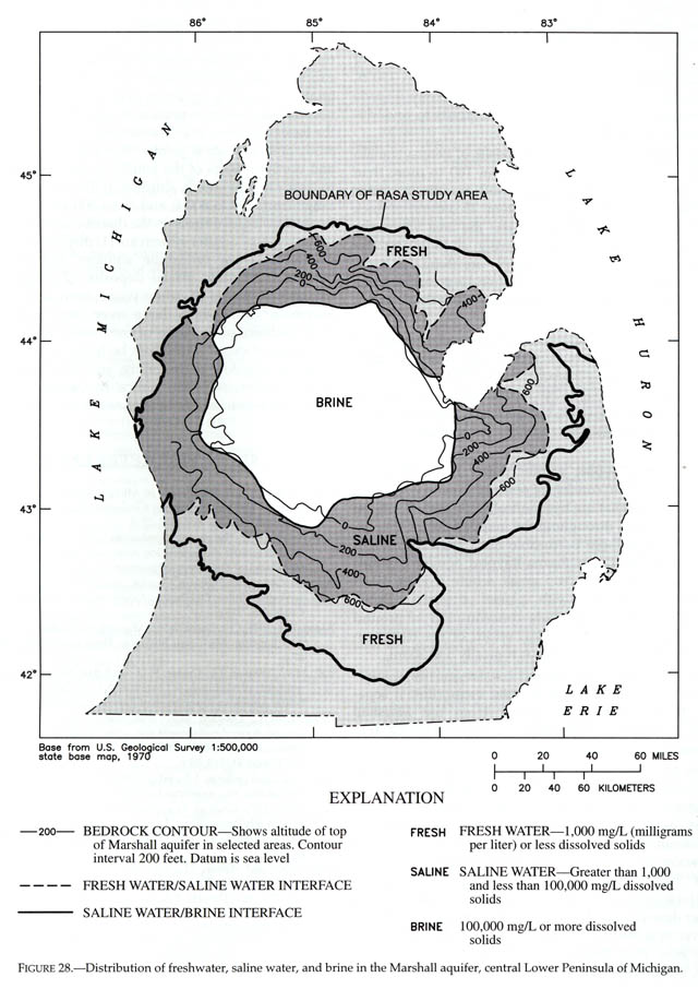
Source: C.M. Davis, Readings in the Geography
of Michigan (1964).
Source: C.M. Davis, Readings in the Geography of Michigan (1964).
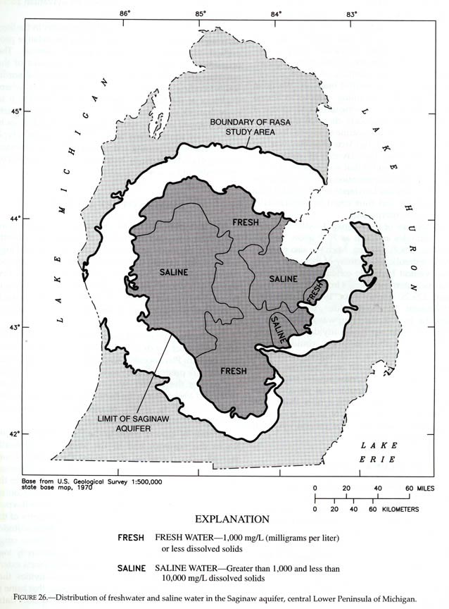
Similar to the Marshall sandstone, and above it, is the Saginaw Formation. It,
too, is a valuable freshwater aquifer that becomes quite saline in the
center of the basin (below).
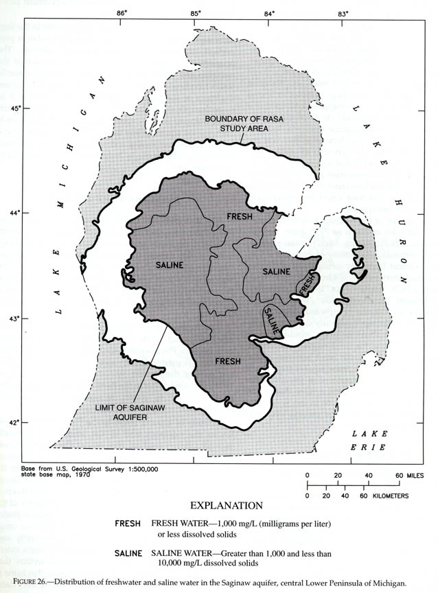
Source: C.M. Davis, Readings in the Geography
of Michigan (1964).
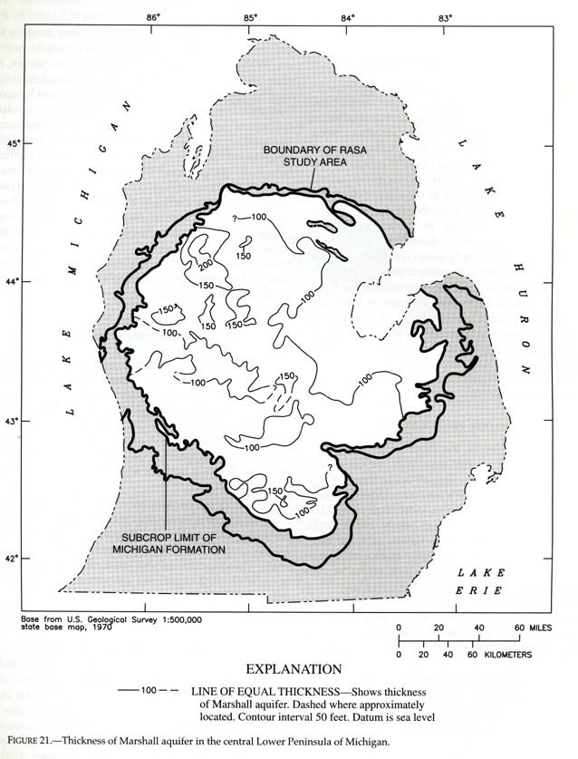
In most places, the Saginaw is 100-200 feet thick (see below).
Source: C.M. Davis, Readings in the Geography
of Michigan (1964).
Some of the Pennsylvanian sandstones have been used for building
purposes-quarries were operated near Flushing, Corunna, Jackson, and Ionia.
Parts of the text above have been paraphrased from C.M. Davis’ Readings in the Geography of Michigan (1964).
This material has been compiled for educational use only, and may not be reproduced without permission. One copy may be printed for personal use. Please contact Randall Schaetzl (soils@msu.edu) for more information or permissions.