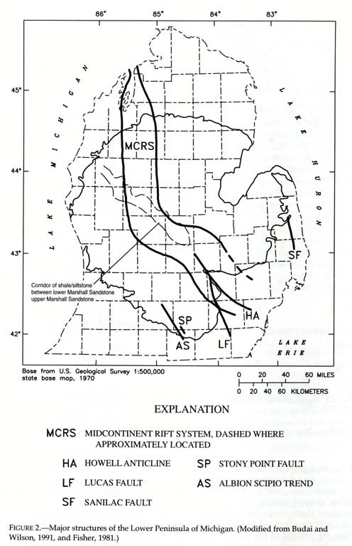
THE MID-CONTINENT RIFT ZONE
On the southern margin of what is today the Canadian Shield a split, or rift occurred
about 1.1 Ga (billion years ago). This is called the Keweenawan Rift, or
mid-continent rift system (see below). In sum, it opened, filled with up to 15 km of
lavas (which solidified into a rock called basalt), and then the rifting stopped (was
aborted). On the edges of the rift, non-volcanic sediments were deposited, perhaps
by rivers flowing into the depressed surface. The rift trough is over 150 km wide
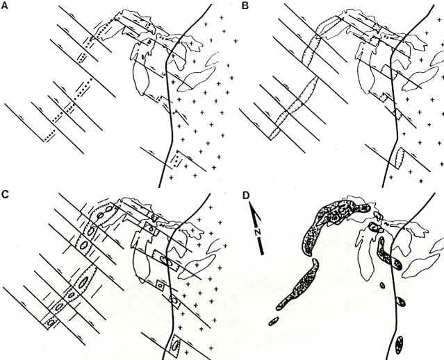
and 1500 km long. The image below shows how the rift may have developed over time.
Source: Unknown
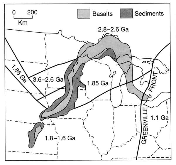
The image below shows approximately where the rift is located, and the ages of the rocks
(formerly lavas, now a rock called basalt) found within it. In the southeastern
shield, from the Great Lakes to southern Greenland, rift-related magmatism began about
1.33 billion years ago and continued episodically for about 230 million years, when
mantle-derived lava up to 16 miles thick flooded the 800-mile-long midcontinent rift that
arcs through Lake Superior. The short time span and large volume of magma effused suggest
that hot mantle plumes impinged on the base of the North American Plate in northwestern
Canada and Lake Superior about 1.27 and 1.10 billion years ago, respectively.
Source: Unknown
Here's an edited excerpt from the book "Annals of the Former
World" that describes this period of geologic time:
If you could have traveled westward from the site of Chicago 1.1
billion years before present (BP), you would have traversed, along the route of Interstate
80, the Precambrian basement rocks of the continent. At 1.108 billion years BP, rifting
(or splitting) of the North American continent began. At around 1.100 billion years BP,
the two parts of the continent were still moving apart and would continue to move apart
for 14 million years more. Something under the core of North America was tearing North
America apart, threatening its continuing existence as an integral continent. It seems
likely that the cause of this Midcontinent Rift was a thermal plume from deep in the
mantle, a geophysical hot spot doming the crust and then cracking it.
Flood basalts filled the rifting valley. At night, above the lava
fountains that would have been coming from the rifting area, the whole sky was red. At
about 1.100 billion years BP, a "triple junction" plate break occurred under
what is now Lake Superior, connecting the southwestern arm of the rift with the arm that
ran through Michigan’s UP and lower peninsula. If the rifting had gone on long
enough, the country between the two active arms---including at least half of what is now
called the Midwest---would have departed from North America to end up who knows where and
in how many pieces. In the middle of North America, a great bay would have developed, with
a shoreline of a thousand miles. But for some reason, the rifting stopped as rapidly as it
began.
Between Lincoln and Omaha, Nebraska, I-80 runs directly over the center
of the rift. It gradually slides toward the rift’s eastern flank at Des Moines. On
I-80, the whole western half of Iowa is over the rift itself or its flanking basins. To
follow this cartographically, you would need the Composite Magnetic Anomaly Map of the
United States. On the magnetic and gravity maps the Midcontinent Rift is the most
prominent feature you see. A quarter-century ago, it was as unknown in scientific mapping.
The rift was referred to as "the midcontinent gravity anomaly" or "the
midcontinent gravity high." These names implied no genesis for the gravity
anomaly, just that it existed. We now know that the gravity anomaly exists due to the
presence of heavier, denser basalts in the rift---which have now become hardened lavas.
If the rifting had continued even for a couple of hundred million
years, as the Mid-Atlantic rifting has done, Lincoln and Des Moines would be as far apart
as Jersey City and Casablanca, whose sites were once as close as Lincoln and Des Moines.
Yet that did not happen. The midcontinent rift system did not, in the end, play a major
role in the evolution of the continent, because the rifting stopped---or was stopped-more
or less abruptly. The rift system’s rocks date from 1.108 to 1.086 billion years BP,
so the rifting lasted 22 million years---not much by comparison with the Atlantic Ocean,
but (to date) about three times the length of time that there has been rifting in the Gulf
of California and longer than the rifting of the Red Sea.
Something seems to have snuffed out the young hot spot, leaving the
midcontinent intact. Where crustal blocks had dropped in the middle of the rift as it
widened, they now were subjected to a compressional force so great that the middle of the
rifts rose up to a position higher than the sides. In the language of geology, grabens
were squeezed upward and became horsts. It was as if the Red Sea were to stop widening,
while its floor came up to stand higher than the shores.
The compressional force that stopped the rift in Proterozoic North
America is believed to have been the Grenville Orogeny. This name has been given to a
continent-to-continent collision, completed by about 1.050 billion years BP, that brought
large continental blocks to collide with the eastern and southern margins of North America
to create the supercontinent Rodinia, hundreds of millions of years before Pangaea, the
most recent of supercontinents. In Grenville time, Africa and South America were neither
configured nor juxtaposed as they would be later on. The edge of this
continent-continent collision zone is called the Grenville Front--see the map above for
its location.
Source: Unknown
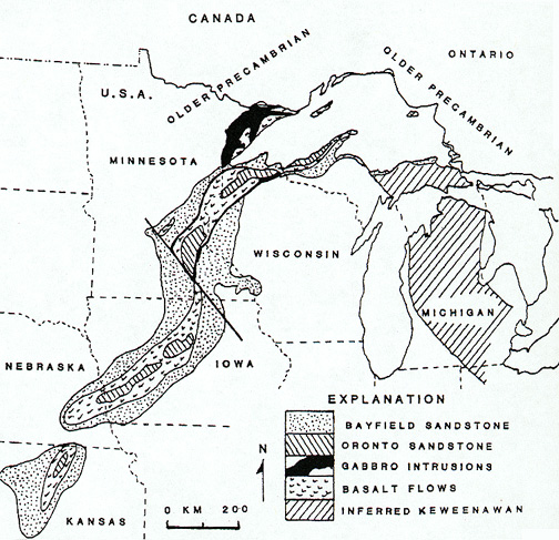
The rift might have looked something like this (below), from the air.
Source: Unknown
Source: Unknown
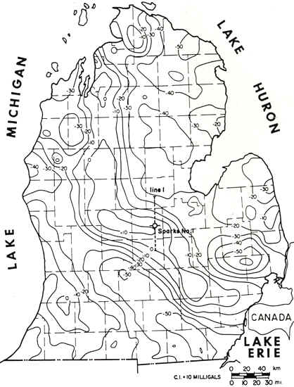
The midcontinent rift valley was first "discovered" by geophysicists,
who noted that gravity was actually "stronger" in certain parts of the midwest.
This gravity pattern, shown below for southern Michigan, followed a line from
Kansas, through the UP, and then curving down through the lower peninsula. Higher
numbers (less negative) imply more gravity, and denser rocks.
Source: Unknown
We now know that this "gravity high" is caused by the dense, heavy lavas (now
dense gabbro and basalt rocks) that fill the rift. Between the rifted areas, lighter
granites are found. The illustration below also suggests that the rift extends
through the lower peninsula, and thus this "lowered area" may also have assisted
in the eventual formation of the Michigan Basin. Compare the map below, of the rift
zone rocks, to the gravity anomaly map above.
Source: Unknown
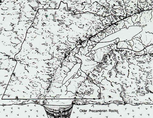
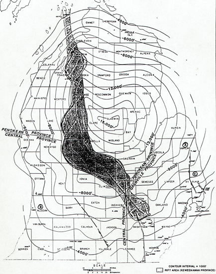
The isolines on the above map are depth in feet from the surface to the Precambrian
bedrock surface. These lines clearly show the outline of the Michigan
structural basin.
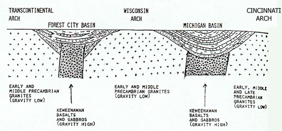
Thus, in conclusion, the rift zone underlies the Michigan basin. In cross section,
such a relationship is shown below.
Source: Unknown
and again here (note where sea level is!):
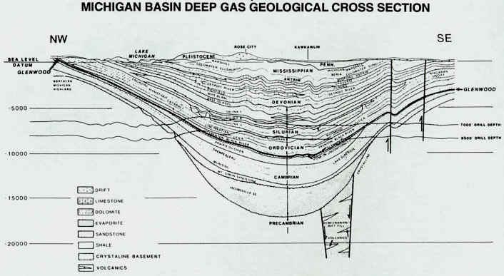
Source: Unknown
Rock formations in the rift zone
As the crust began to rift or split apart, volcanoes became active in
the western Lake Superior region and violently ejected volcanic cinder, ash, and bombs.
Then, somewhat subdued, these volcanoes poured out lava from long vents in quiet eruption.
This lava is today called the Portage Lake Lava formation.
When the eruptions subsided, winds and weather broke up the lava flows
into pebbles, gravel, sand, and fine muds, which became cemented together in a rock we
call conglomerate, which would later form a rock called the Copper Harbor Conglomerate.
In places the sands and fine muds became sandstones and shales, the Freda Sandstone
and the Nonesuch Shale. Lava flows covered the conglomerates, more conglomerates
were formed; they in turn were covered until several thousand feet of conglomerates and
lava flows with sandstones and shales were built up. In the gas bubbles (amygdules) on top
of the lava flows, in the cracks of the lavas and conglomerates, nature stored pure copper
and silver and many interesting and beautiful copper minerals, the treasure store of
Keweenaw, Houghton, and Ontonagon counties. The time in which these volcanic events were
occurring is named the Keweenawan, the last part of the Precambrian era in Michigan.
Finally, on top of all these sediments that were accumulating in the
rift zone, more sand was laid down, which eventually hardened into the beautiful, red,
white and
brown, Jacobsville Sandstone. This sandstone is widely used in the region
as a building stone.
SIDE NOTE: Bill Heinze, an MSU geophysicist, was one of the people who helped discover the extent (2000 miles mostly subsurface) of the midcontinent rift zone. Dr. Heinze helped develop the airborne gravity and magnetic studies that flew over the US in the late fifties and 60's. It was his work in conjunction with USGS that identified the Midcontinent Gravity Anomaly that later turned out to be the midcontinent rift.
This material has been compiled for educational use only, and may not be reproduced without permission. One copy may be printed for personal use. Please contact Randall Schaetzl (soils@msu.edu) for more information or permissions.