OUTWASH PLAINS
The large quantities of water that flowed from the melting ice deposited various kinds of
materials, the most important of which is called glacial outwash. Outwash plains made up
of outwash deposits are characteristically flat and consist of layers of sand and other
fine sediments. Such plains with their sandy soils are often used for specialized kinds of
agriculture, such as the potato production in Montcalm County.
As the margins of the ice lobes retreated, glacial meltwater and
precipitation drained southward to the Gulf of Mexico because higher land or glacial ice
blocked flow in other directions. Ice-marginal lakes (or proglacial lakes) form when the
land in front of the ice margin slopes toward the ice, allowing meltwater to pond
directly in contact with the ice, as shown below.
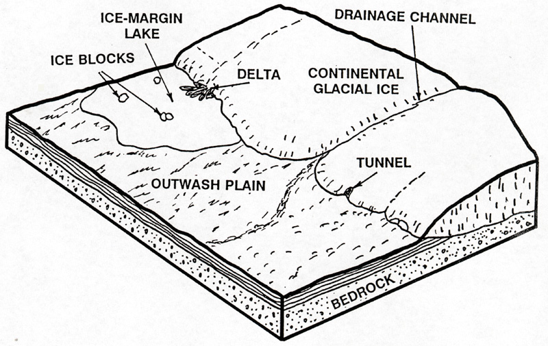
However, when the land sloped away from the ice, as was the case in most of
extreme southern Michigan, and in certain locations elsewhere, water could not pond in
front of it. Instead, meltwater streams formed, washing sediment out, away from the
ice. Sand and gravel, which these streams could
not carry, was laid down as outwash, in broad, flat outwash plains (see the diagram
above).
Rapid melting of the ice as it stood at end moraines produced rapidly-flowing, broad
sheets of water along the ice front. Moving swiftly over the morainic material, the water
worked it over, sorted it, carried it out from the moraine, and as the currents slackened,
dropped the sorted debris, leaving the coarse cobbles, gravel and sand – spread in
that order in front of the moraine. These stratified gravelly, gently undulating to flat
plains are called outwash plains — they can be best seen as the flat lands of
Kalamazoo, Cass, and Roscommon counties and those around Baldwin, Cadillac, and Grayling.
Although resembling each other, outwash and till plains are readily differentiated. A till
plain is behind (towards the direction of retreat) of a moraine, and the outwash plain is
in front of the moraine. A till plain is composed of unsorted material (till) of all sizes
with much clay, an outwash plain is mainly stratified (layered and sorted) gravel and
sand. The till plain has a gently undulating to hilly surface; the outwash is flat or very
gently undulating where it is a thin veneer on the underlying till. As a rule flourishing
farms are on the till plains; the majority of abandoned farms in the northern part of the
Lower Peninsula are on sandy outwash plains. Hardwood forests grow on till plains;
conifers on the outwash plains.
Outwash plains were built over the top of landscapes that had been only
recently deglaciated, and hence some ice blocks from that previous ice advance often still
lay on the landscape. Some of these ice blocks became buried by outwash sand as
sedimentation continued and their melting was delayed for hundreds of years. Eventually
the debris-covered ice melted and left basins which have since been filled with water and
form "pit" lakes. Higgins Lake, Gull, Cadillac, and many other lakes, are in
depressions of "pitted outwash." Probably all such pits were once filled with
water but many of them are now swamps, others are dry basins, and others are represented
by the patches of black soil on till or outwash.
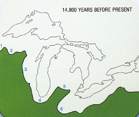
The map above shows that, as of about 14,800 years ago, the ice margins were positioned
such that meltwaters flowed away from the ice (were not ponded in front of it).
Thus, large outwash plains formed, and can be seen today as flat, sandy plains in many
parts of Cass, St. Joseph, and Hillsdale Counties.
Cutover forest lands are frequently found on outwash plains. From this we may get the
impression that all outwash plains are waste land. However, broad stretches of outwash
make up the farm lands between the Tekonsha, Kalamazoo, Valparaiso moraines and others in
the southwestern part of the State. In the southwestern part of the State the early
settlers found large unforested, very fertile, areas which they called "oak
openings" or prairie. They are situated mainly on outwash plains. If irrigated, these
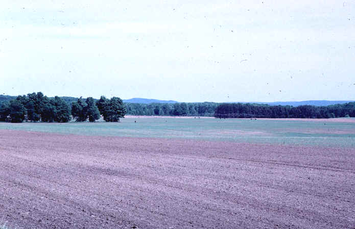
outwash plains provide very fertile farmland. The image below is of a sandy,
irrigated outwash plain, with a large end moraine in the
background.
In places, glacial meltwater flowing from the ice was confined to
channels, and cut spillways through the moraines or was forced to flow in a narrow channel
along the ice front. Melt water, so restricted, built valley trains in the drainageways
--- deposits of stratified sand and gravel which extended out from and along the borders
of the ice. They are similar to the outwash in material and structure, but usually quite
limited in extent. Outwash plains are wide and formed in places where the water flowed out
in a relatively unrestriced manner; valley trains are long and narrow and formed in
restricted valleys. Otsego Lake, in Otsego County, is in a wide valley train. Many old
pre-glacial valleys in the western half of the Northern Peninsula were either wholly or in
part filled with valley train deposits.
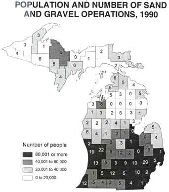
Today, outwash plains are one of Michigan's main sources of aggregate--sand and gravel. The map below shows how sand and
gravel operations are located near large population centers.
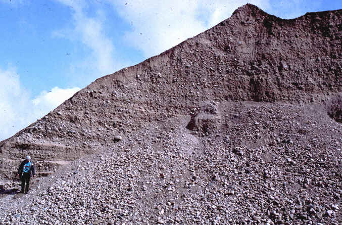
Note, in the image below, the large proportion of gravel in this outwash sediment.
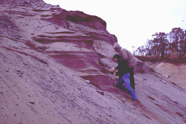
In other areas, outwash is mostly sand (below), and hence of less value. In all
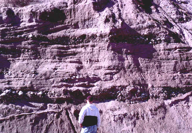
instances, however, the outwash sediment has been stratified (sorted into distinct layers)
by the running glacial meltwater.
This material has been compiled for educational use only, and may not be reproduced without permission. One copy may be printed for personal use. Please contact Randall Schaetzl (soils@msu.edu) for more information or permissions.