The Great Lakes are part of the global hydrologic system.
Prevailing westerly winds continuously carry moisture into the basin in air masses from
other parts of the continent. At the same time, the basin loses moisture in departing air
masses by
evaporation and transpiration, and through the outflow of the St. Lawrence River. Over
time, the quantity lost equals what is gained, but lake levels can vary substantially over
short-term, seasonal and long-term periods.
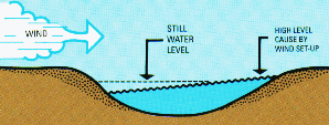
Day-to-day changes are caused by winds that push water on shore. This is called 'wind
set-up' and is usually associated with a major lake storm, which may last for hours or
days. Another extreme form of oscillation, known as a 'seiche', occurs with rapid changes
in winds and barometric pressure. During storms, high winds and rapid changes in
barometric pressure cause severe wave conditions at shorelines.
Annual or seasonal variations in water levels are based mainly on
changes in precipitation and runoff to the Great Lakes. Generally, the lowest levels occur
in winter when much of the precipitation is locked up in ice and snow on land, and dry
winter air masses pass over the lakes enhancing evaporation. Levels are highest in summer
after the spring thaw when runoff increases.
The irregular long-term cycles correspond to long-term trends in
precipitation and temperature, the causes of which have yet to be adequately explained.
Highest levels occur during periods of abundant precipitation and lower temperatures that
decrease evaporation. During periods of high lake levels, storms cause considerable
flooding and shoreline erosion, which often result in property damage. Much of the damage
is attributable to intensive shore development, which alters protective dunes and
wetlands, removes stabilizing vegetation, and generally reduces the ability of the
shoreline to withstand the damaging effects of wind and waves.
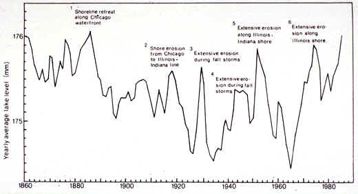
The level of the water in the five Great Lakes has a tremendous impact on the users
of
those water bodies. Low lake levels causes problems with harbors (the water is too
shallow for many boats) and the rivers that drain into them. High lake levels cause
bank and bluff erosion. The chart below shows the periods of high and low lake
levels during the past 130+ years.
The Great Lakes' Hydology web
page provides up-to-date information on lake levels.
What factors affect lake levels? Hydrologically, lake levels can be viewed as being
a function of several factors:
LL=gains (P+R+I+Di) minus losses (ET+O+GW+Do)
LL = lake level
P = precip directly onto lakes (about 30-32 inches)
R = runon from land
I = inflows from rivers
Di = diversions of water into the lakes
(I is largely a function of land use within the basin and intensity of precipitation that
falls on the basin)
ET = evapotranspiration from lakes
ET = f (summer temps, winter ice cover, winter temps, winds in all seasons,
sunshine, etc.)
O = outflows in rivers at lake outlets
GW = losses to groundwater
D = diversions for municipalities and other consumptive uses, out of the lakes
D = f(dredging outlets such as the St. Clair River, diversions for drinking water and
hydro power,
regulating structures like dams and locks)
The International Joint Commission, the binational agency established under the Boundary
Waters Treaty of 1909 between Canada and the U.S., has the responsibility for regulation
of flows on the St. Marys and the St. Lawrence Rivers. These
channels have been altered by enlargement and placement of control works associated with
deep-draft shipping. Agreements between the U.S. and Canada govern the flow through the
control works on these connecting channels.
The water from Lake Michigan flows to Lake Huron through the Straits of
Mackinac. These straits are deep and wide, resulting in Lakes Michigan and Huron standing
at the same elevation. There are no artificial controls on the St. Clair and Detroit
Rivers that could change the flow from the Michigan-Huron Lakes system into Lake Erie. The
outflow of Lake Erie via the Niagara River is also uncontrolled, except for some diversion
of water through the Welland Canal. A large percentage of the Niagara River flow is
diverted through hydroelectric power plants at Niagara Falls, but this diversion has no
effect on lake levels.
The responsibilities of the International Joint Commission (IJC) for
levels and flows of the Great Lakes are separate from its responsibilities for water
quality. Water quality objectives are set by the Great Lakes Water Quality Agreement, but
decisions about levels and flows are made to comply with the terms of the l909 Boundary
Waters Treaty.
Only limited controls of levels and flows are possible and only for
Lake Superior and Lake Ontario. The flows are controlled by locks and dams on the St.
Marys River and in the St. Lawrence. Special boards of experts advise the IJC about
meeting the terms of the treaty. Members of the binational control boards are equally
divided between government agencies in both countries. Until l973, the IJC managed levels
and flows for navigation and hydropower production purposes. Since then, the IJC has tried
to balance these interests with prevention of shore erosion.
The IJC has carried out several special studies on levels issues in
response to references, or requests, from the governments. In l964, when water levels were
very low, the governments asked the IJC whether it would be feasible to maintain the
waters of all the Great Lakes, including Michigan and Huron, at a more constant level.
After a 9-year study, in l973, when water levels were very high, the IJC advised the
governments that the high costs of an engineering system for further regulation of
Michigan and Huron could not be justified by the benefits. The same conclusion was reached
for further regulation of Lake Erie in l983.
Two human activities, diversion and consumptive use, have potential for
affecting lake levels, although they have had relatively little impact to date. Diversion
refers to transfer of water from one watershed to another. Consumptive use refers to water
that is withdrawn for use and not returned. Most consumptive use in the Great Lakes is
caused by evaporation from power plant cooling systems.
At present, water is diverted into the Great Lakes system from the
Hudson Bay watershed through Long Lac and Lake Ogoki, and diverted out of the Great Lakes
and into the Mississippi watershed at Chicago. These diversions are almost equally
balanced and have had little long-term effect on levels of the lakes.
In l982, the IJC reported on a study of the effects of existing
diversions into and out of the Great Lakes system and on consumptive uses. Until this
study, consumptive use had not been considered significant for the Great Lakes because the
volume of water in the system is so large. The study concluded that climate and weather
changes affect levels of the lakes far more than existing human-made diversions. However,
the report concluded that if consumptive uses of water continue to
increase at historical rates, outflows through the St. Lawrence River could be reduced by
as much as 8 percent by around the year 2030.
Lake levels vary from year to year and can be expected to continue to
do so. "We need to accept that we can't control the Great Lakes like we would a
little inland lake," said Dr. Michael J. Donahue, director of the Great Lakes
Commission, in Ann Arbor.
Following the period of high lake levels in the 1980s, the IJC
conducted another study of levels and the feasibility of modifying them through various
means. In 1993, the study concluded that the costs of major engineering works to further
regulate the levels and flows of the Great Lakes and St. Lawrence River would exceed the
benefits provided and would have negative environmental impacts. Instead, it recommended
comprehensive and coordinated land-use and shoreline management programs throughout the
basin that would help reduce vulnerability to flood and erosion damages.
Why do lake levels vary so much?
Theories for lake cycles abound. Scientists agree, however, that strong evidence
shows a yearly high-to-low cycle, and a second, larger cycle with deeper peaks and depths
that occurs roughly every 30 years. A third and more tentative theory points to
extremely deep lows arriving every 150 years.
As a rule, lakes swell to their highest in summer, as spring melting
rolls down the system. Levels sink to their lowest in winter, when snow piles up and
freezes flows from tributaries. This tends to be a reliable annual pattern. But
there are broader patterns of lake declines that seem to take place about every 30 years.
When historic lows were set on Lakes Michigan and Huron in 1964, the word drought
was used freely by journalists and scientists. That year, residents near Lake
Charlevoix were treated to a scene from Michigan's logging past. Axes, sawmill tools
and millions of feet of sunken boards from the mid-1800s came to light from the lake's
drying bed. Similar severe lows for Lakes Erie and Ontario came in 1934, three
decades before 1964.
In the search for an even longer-term pattern, one theory poses that
extended lows occur every 150 years. Indiana geologists studying Lake Michigan sand
dunes are digging into beach ridges, checking the ages of ridge sediments and charting
periods of lake lows and highs. They discovered that Michigan's waters have fallen
more than 12 feet in the past 4,500 years. Other studies of Lake Superior's ridges are
under way. Early results show Lake Michigan may fluctuate by as much as 4 feet during the
150-year swings.
What to do?
One planning strategy for dealing with variations in lake
levels is relocation of cottages and buildings at risk from unstable shores, an idea that
outrages many lakeside property-rights groups. "We are not the problem. We are a
persecuted political minority living in two countries, in a zone 300 feet wide and
thousands of miles long," declared Bill Andresen, a South Haven engineer with
beachfront property on Lake Michigan. Andresen is president of the International Great
Lakes Coalition, a group of shoreline owners mostly from Michigan. "Our assets are on
the line," he said. "Lake levels have been kept artificially high for the past
three decades to please the interests of the utilities and commercial shipping."
The coalition, which includes lawyers and civil engineers, has hatched
a solution of its own. It is petitioning (as of 2000) Canadian and American
officials to build a $50-million water retainment wall between Lake Erie and Lake Ontario,
on the Black Rock Canal along the Niagara River near Buffalo, N.Y. The structure would
allow closer control of lake waters, more consistent flow to hydropower generators and
keep Lakes Huron and Michigan at predictable levels for residents, they argue. But the
Canadian-American body with the power to approve the plan has politely declined.
Members of the International Joint Commission, in charge of all
boundary waters between the two nations, have studied and rejected more than 150 bids to
mechanically control the lakes.
As they are, the lakes are regulated at only two points: Sault Ste.
Marie on Superior and at Massena, N.Y., on Lake Ontario. Commission engineers rejected the
plans because they concluded economic and environmental effects from new controls would be
unequal on each lake. "Regulation is no longer the answer," agreed Mark Wyckoff
of a private consulting firm in Lansing. He advocates construction setbacks from shore,
movable structures and disclosure laws in handling property-rights claims. "We're
dealing with Mother Nature in a lake system that is just so huge in scale," he said.
"You don't try to change that, you adapt. Let the shoreline buyer beware."
Past lake extremes have prompted still other solutions. During record
lake lows in 1964, Sen. Philip Hart of Michigan asked Canadian officials to consider
sluicing water from their distant rivers into the Great Lakes system. He reasoned that
"unused" water in Hudson Bay could be better employed. The Canadians curtly
refused. Scientists stress that diversions from Canada and similar plans tend to be crude
and expensive. They rarely account for variations in rain and snowfall in the Ontario
watershed, lake evaporation or for warming patterns seen in weather worldwide.
Environmental groups object on another front, arguing that water diversions to or from the
lakes only trade problems between regions. Diversions also create expectations among
residents impossible to sustain over time, they say.
Another perspective...
Each and every day, customers of the Detroit water system
throughout Wayne, Oakland, Macomb, St.Clair, Lapeer, Genesee, Washtenaw and
Monroe Counties consume an average of 675 million gallons of water. That’s a
lot of water. Yet consider for a moment what a recent report prepared by one
of the top coastal engineering firms in North America theorizes: that 845
million gallons of water is being lost every day because erosion in the St.
Clair River has allowed water to flow more quickly out of Lakes Michigan and
Huron. This study and others also show a permanent drop of as much as 12
inches in the long-term average levels of those lakes. When lake levels are
low, this loss of water can have devastating and costly consequences for
homeowners and boaters, as well as for fish and wildlife that depend on
coastal habitat for spawning or nesting grounds.
The study points to massive dredging in the St. Clair River during
the early 1960s to open the upper lakes to shipping, which has been a huge
economic impetus for our state and our region. The study theorizes that
subsequent dredging and erosion have had the effect of pulling the plug out
of a bathtub, dramatically speeding up the flow of water that eventually
runs through the St. Lawrence Seaway and out into the Atlantic Ocean.
Engineers who completed the study believe that removing the hardened top
layer of the river bottom exposed softer material that was easily washed
away by the increased flow and has resulted in nearly doubling the depth of
the channel, for example, just south of the Bluewater Bridge. The U.S. Army
Corps of Engineers, while acknowledging a change in the river flows,
believes other factors may be the reason. Obvious factors come from Mother
Nature, when she gives us more or less rainfall and snowfalls. Or it could
be the way Michigan has rebounded (isostatic rebound) from the weight of the
glaciers, when they left some 10,000 years ago. Another factor might be a
reduction in sand supply to the St. Clair River caused by shoreline
protection measures built along the shores of Lake Huron and harbor
construction near the mouth of the river.
The Great Lakes comprise fully one-fifth of the freshwater supply
to the entire planet. Michigan, the Great Lakes State, looks to the lakes
for its economic well-being, its quality of life and its very identity. Even
at today’s prices, a gallon of oil is far cheaper than a gallon of bottled
water; and although we could live without oil, life cannot be sustained
without water. We shake our fists at one who threatens water diversion, and
yet the amount of water being diverted, according to this study, is more
than any suggested plan of diversion that another part of the country could
even contemplate.
The article above was written by Candice Miller, Published in the Lansing State Journal, April, 2005 (and slightly edited here)
Parts of the text on this page have been modified from the NOAA Publication, "The Great Lakes An Environmental Atlas and Resource Book" (1995), and from an article in the Detroit News ("Our Lakes in Peril. Sources and Solutions" Aug 25, 1999).
This material has been compiled for educational use only,
and may not be reproduced without permission. One copy may be printed for
personal use. Please contact Randall Schaetzl (soils@msu.edu)
for more information or permissions.