LAKE ERIE
Lake Erie is the smallest of the Great Lakes in volume (116 cubic miles) and is exposed to
the greatest effects from
urbanization and agriculture. Measuring 241 miles across and 57 miles from north to south,
the lake's surface is just under 10,000 square miles, with 871 miles of shoreline. The
average depth of Lake Erie is only about 62 feet (210 feet, maximum). It therefore warms
rapidly in the spring and summer, and frequently freezes over in winter. The drainage
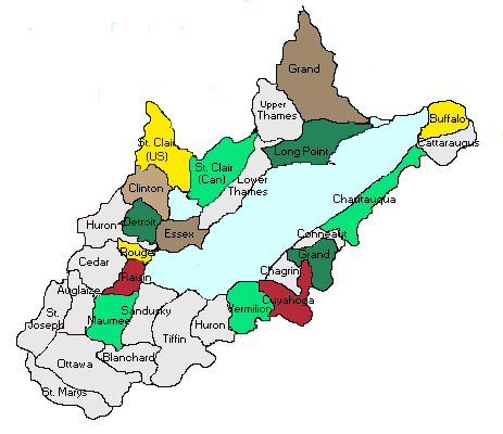
basin covers parts of Indiana, Michigan, Ohio, Pennsylvania, New York and Ontario. Because
of its fertile soils, the basin is intensively farmed and is the most densely populated of
the five lake basins. Numerous, short rivers drain into Lake Erie. The lake itself
is quite shallow, and the rivers that drain into it flow on clay-rich landscapes, all
leading to the possibility of high sediment loadings in the lake. Most of the rivers that
drain into Lake Erie, from Michigan, rise in the interlobate moraine that runs between
Jackson and Pontiac. Examples include the Huron and Clinton Rivers.
FACTS
Length - 241 miles / 388 km
Breadth - 57 miles / 92 km
Ave. Depth - 62 ft. / 19 m.
Max. Depth - 210 ft. / 64 m.
Volume - 116 cubic miles / 484 cubic km.
Water Surface Area - 9,910 sq. miles / 25,700 sq. km.
Drainage Basin Area - 30,140 sq. miles / 78,000 sq. km.
Shoreline Length (including islands) - 871 miles / 1,402 km.
Elevation - 569 ft. / 173 m.
Outlet - Niagara River and Welland Canal
Retention/Replacement Time - 2.6 years (shortest of the Great Lakes)
Name - The greater part of its southern shore was at one time occupied by the Eries, a
tribe of Indians from which the lake derived its name. This name is always mentioned by
the early French writers as meaning "cat"; Lac du Chat means "Lake of the
Cat." Many attribute this reference to the wild cat or panther.
Lake Erie is the eleventh largest lake in the world (by surface area).
It is the fourth largest of the Great Lakes in surface area and the smallest by volume.
Ninety-five percent of Lake Erie's total inflow of water comes via the Detroit River water
from all the "upper lakes" -- Superior, Michigan and Huron -- the St. Clair
River, Lake St. Clair and numerous tributaries. The rest comes from precipitation. Lake
Erie is the shallowest of the Great Lakes and is especially vulnerable to fluctuating
water levels.
Wind setups (wind pushing the water from one end of the lake toward the other), usually
from west to east, have produced large short- term differences in water levels at the
eastern and western ends of the lake, the record being more than 16 ft (4.88 m).
The water provided by Lake Erie for waterborne commerce, navigation, manufacturing, and
power production has led to intensive industrial development along its shore, but the
basin's moderate temperatures have also encouraged recreation and agriculture.
Lake Erie is the warmest and most biologically productive of the Great Lakes, and the Lake
Erie walleye fishery is widely considered the best in the world.
Point Pelee National Park in Lake Erie is the southernmost point on Canada's mainland.
This material has been compiled for educational use only, and
may not be reproduced without permission. One copy may be printed for personal
use. Please contact Randall Schaetzl (soils@msu.edu)
for more information or permissions.