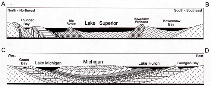
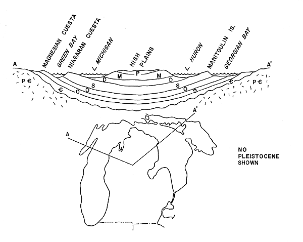
The diagram below shows what the structure of the rocks would look like, along transects A-B and C-D.
GEOLOGY
The underlying bedrock of Michigan is mostly hidden from view by unconsolidated
material deposited during continental glaciation. However, there are a number of places in
the Lower Peninsula where the bedrock can be seen such as in rock quarries and in outcrops
along rivers and lakes. In the western Upper Peninsula, a considerable amount of bedrock
is visible.
The geologic formations of Michigan span more than 3.5 billion years,
from some of the oldest Precambrian rocks to loose, unconsolidated drift left behind by
the continental ice sheets of the Pleistocene period.
Source:
Image Courtesy of Randy Schaetzl, Professor of Geography - Michigan State
University
The diagram below shows what the structure of the rocks would look like, along transects
A-B and C-D.
Source:
Unknown
Two major rock types are found in Michigan. The Lower Peninsula and the eastern parts
of the Upper Peninsula are underlaid by a series of sedimentary rock layers: The Michigan
Basin. These rock formations, consisting largely of shales, limestones, and sandstones,
were deposited on the bottom of ancient seas that covered Michigan on and off for millions
of years. The basin is estimated to be about 14,000 ft (4,267 m) thick, and its rocks rest
on the top of a very old Precambrian surface. The various layers of sedimentary rock are
piled up on top of one another like a series of saucers.
The ancient igneous and metamorphic rocks that compose the Precambrian,
or Canadian, Shield in the western part of the Upper Peninsula make up the second category
of rocks and are estimated to be at least 3.5 billion years old. The igneous rocks are
hard, crystalline, resistant to erosion, and are largely made up of granites and
metamorphic rocks--rocks that have been changed through heat and pressure--composed mainly
of gneisses and schists. The higher areas in the Upper Peninsula are the remnants of
ancient peaks that have been worn down over millions of years by the erosive action of
wind, water, and moving ice. Thus, the Porcupine and Huron mountains in the western half
of the Upper Peninsula have been greatly altered over their long geologic history through
uplift and erosion and are now only remnants of once-high mountains.
Both major types of rocks found in Michigan are important to humans.
The igneous type contains valuable minerals such as iron ore and copper, and the
sedimentary rocks contain petroleum, natural gas, salt, gypsum, and limestone.
Source: Unknown
Source: Unknown
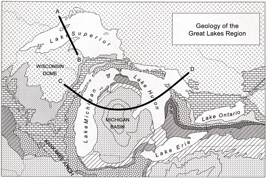
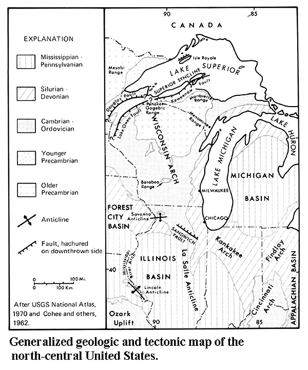
The major rock structures of the Great lakes region are shown in the map below. Notice the
Michigan Basin, the Keweenaw
Fault, the Superior Syncline, the Kankakee, Findlay and Cincinnati Arches, and the three
iron ranges of the UP. The Wisconsin
Dome is labelled the "Wisconsin Arch" on the map.
Source: Unknown
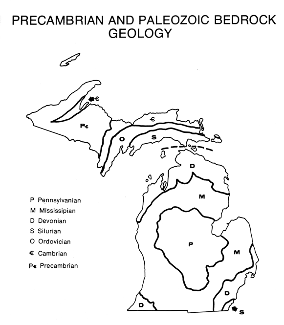
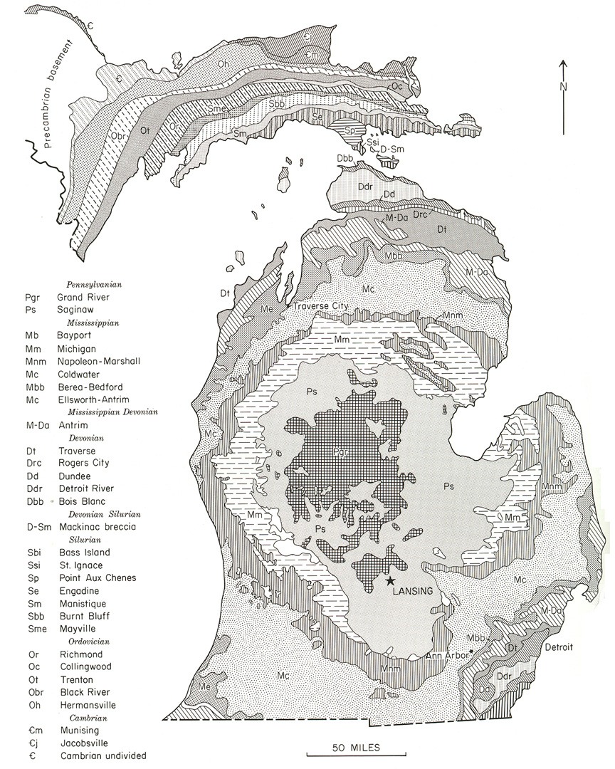
And finally, the map below is a detailed depiction of the Paleozoic rocks of Michigan.
Source: Unknown
As you now know, the geology of Michigan is dominated by two rock formations: the
sedimentary Michigan Basin, which covers the entire Lower Peninsula and the eastern half
of the Upper Peninsula, and the old crystalline, igneous shield found in the western Upper
Peninsula. These rocks are covered to various depths by material deposited during the Ice
Age. The preglacial topography was much disturbed by the power of these vast ice sheets as
they eroded and leveled certain areas and deposited materials in other sections of the
state. The present surface is characterized by ridges of sand, gravel, and clay known as
moraines, which were deposited as the ice advanced and retreated in the state.
Within the major landform regions, the great variety of glacial
features, each used somewhat differently by humans, results in a large number of smaller
regions, some even microscopic in size. In a small area, such as a county, three of four
or more local landform categories can be identified.
Parts of the text on this page have been modified from L.M. Sommers' book entitled, "Michigan: A Geography".
This material has been compiled for educational use only, and may not be reproduced without permission. One copy may be printed for personal use. Please contact Randall Schaetzl (soils@msu.edu) for more information or permissions.