EVAPORITES: GYPSUM AND HALITE (ROCK SALT)
The Michigan Basin is one of the greatest areas of
rock salt (and other evaporites like gypsum) in the world, and these sediments have been the basis
of major chemical and plasterboard industries in Michigan. How did these sediments come to
accumulate in such great thicknesses in southern Michigan?
During the early and middle Silurian, an extensive blanket of limestone
was deposited from New York State west at least as far as Wisconsin. Within this area of
carbonate deposition, however, some localities subsided much more rapidly than others. One
of the areas of subsidence was located under what is now lower Michigan. Indeed, the
development of the Michigan Basin is the dominant feature developed in the Great Lakes
region during the Silurian.
Earlier, during the Cambrian and Ordovician periods, one rather
elongated basin extended from Missouri northeastward through Illinois and lower Michigan.
This basin was bounded on the northwest by the Wisconsin Arch and on the southeast by the
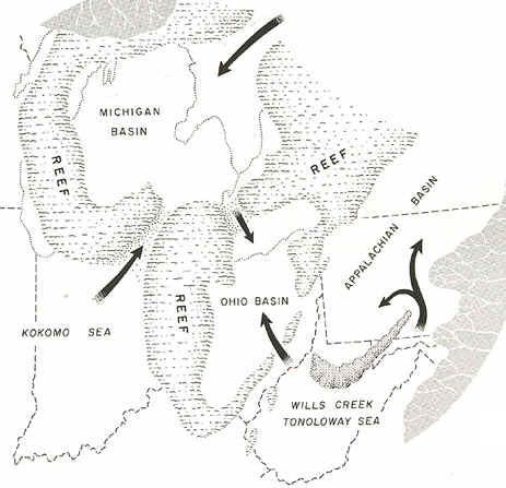
Cincinnati Arch. During the middle Silurian the Kankakee Arch developed across
northeastern Illinois, forming two separate basins. Although it did not form a land
barrier, it greatly restricted circulation of sea waters within the Michigan Basin.
Source: C.M. Davis, Readings in the Geography of Michigan
(1964).
The rate of subsidence within the Michigan Basin then increased
markedly, and a series of coral reefs developed along
the Kankakee Arch and in the shallow waters along the western and southern margins of the
basin. Some of these reefs can be seen today on the south side of Chicago, and I-94
crosses over a giant quarry into one of them. Assuming that the Silurian reefs formed in
an environment similar to modern reefs, we can infer something about the Great Lakes area
during this time. All modern reefs grow on a shallow bottom, no deeper than the depth of
light penetration (generally about 60 m). Furthermore, coral reefs are restricted to
tropical regions where water temperatures are consistently above 77oF. Thus,
the presence of extensive reefs around the Michigan Basin during the Silurian suggests a
shallow tropical or sub-tropical environment. Well-preserved fossils in most of these
ancient reefs substantiate this assumption. Outward from the reefs, in the deeper water,
muds rich in CaCO3 accumulated on the floor of the vast shallow seas, generally
producing thinly bedded dolomite that contains few fossils.
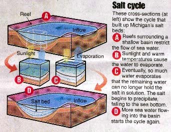
But the genial climates of the Silurian came to an end. The close of
the Silurian was a long time of aridity in which the seas became so salty that living
creatures swam to a more suitable home. The conditions were roughly analogous to the
present-day Mediterranean Sea where water from the Atlantic flows in over the rather
shallow restriction at the Straits of Gibraltar. The arid climate in the region evaporates
the sea water and concentrates the salt. The heavier, highly saline water sinks to the
bottom and cannot escape and therefore tends to accumulate. Great salt beds (named the
Salina Salt Beds) were deposited in the basin. In the central part of the basin 2300 feet
of alternating salt, shale, and limestone beds have been penetrated in the Salina, with
1600 feet of rock salt. The rock salt bowl becomes thinner towards its rim.
Source: Detroit Free Press
Thus, visualize a subsiding, circular basin in lower Michigan,
surrounded by shallow waters and coral reefs. At that time the Great Lakes area was near
the equator, and as a result, there was extensive evaporation of sea water. To make up for
this, salt water was constantly being added to the Michigan (evaporation) Basin through
shallow passages in the reefs. Waters in the basin were therefore saltier than in the
"open ocean" outside of the basin. Since the higher salt concentration caused
the water to become heavier, the highly saline water settled to the bottom of the basin
rather than mixing with the inflowing fresher waters from the surrounding seas.
Source: C.M. Davis, Readings in the Geography of Michigan (1964).
In this way, salt concentrations in the Michigan Basin grew, until
gypsum (CaSO4•2H2O), anhydrite (CaSO4), and finally
rock salt (NaCl) were precipitated on the underlying carbonates. An aggregate thickness of
600 m of gypsum and salt accumulated in the basin, with one bed of salt nearly 150 m
thick. It would take a column of sea water nearly 1000 km deep to form a layer of salt 600
m thick. Great thicknesses of anhydrite and gypsum are also present. The deposition of
this immense volume of salt took perhaps 15-20 million years and ended about 390 million
years ago.
Source: C.M. Davis, Readings in the Geography of Michigan (1964).
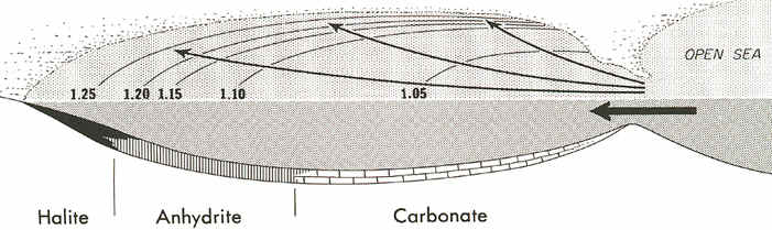
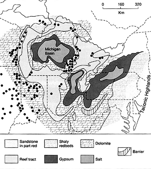
The map below shows the North American Silurian reef system. The dots represent Silurian reefs. During the mid-Silurian, pinnacle reefs surrounded the edges of the Michigan basin. Each reef extended up, vertically, from the sea floor, some 200+ meters. They commonly are up to a km in width. Today, these reefs are important oil and gas "traps", and because the limestone in them is so hard and pure, the reefs themselves (when close to the surface) are important sources of limestone. The large quarry on the south side of Chicago, the Thornton Quarry, is crossed by I-94; perhaps you have driven across it! While these reefs were forming, limestone and dolomite were precipitating in the deep waters of the basin, but near the "inlets" to the basin. In the farthest and cleanest parts of the basin, however, halite salts and gypsum salts (anhydrite) were precipitating out in sedimentary beds (see below).
Source: C.M. Davis, Readings in the Geography of Michigan (1964).
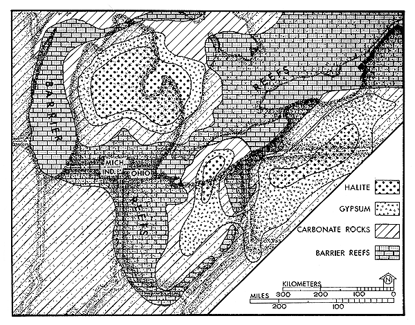
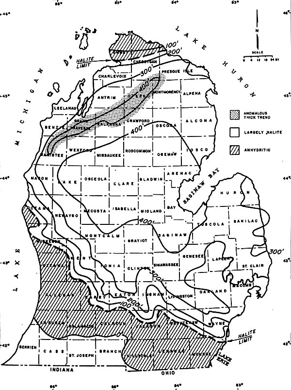
The map below shows the thickness of one of the salt deposits, the Salina Salt, in
southern Michigan. The salt is thickest (over 400 feet thick!) where the basin was,
presumably, deepest. One notable exception to this trend exists in NW Lower Michigan,
where a 400+ foot thick layer extends to the SE of the barrier reefs that also exist
there.
Note also that this salt is predominantly halite in the center of the basin, and has more anhydritic characteristics at its edges.
THICKNESS OF THE SALINA SALT IN THE MICHIGAN BASIN
Source: C.M. Davis, Readings in the Geography of Michigan (1964).
The extensive development of offshore carbonate rocks and an absence of sandstones and shales suggests that no landmass was present in the Great Lakes area while these deposits were being formed.
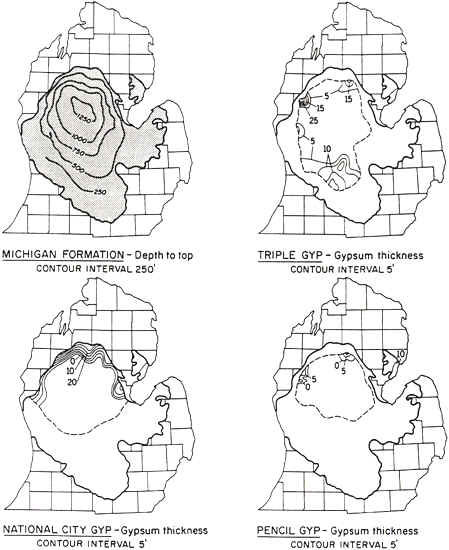
In a similar fashion, the map below shows the thickness of some of the various gypsum
beds in the Michigan Basin, and the depth of burial (in feet) of some of these deposits.
Source: C.M. Davis, Readings in the Geography of Michigan (1964).
Most gypsum units (as the maps show) are less than 20 feet in thickness. Contrast that
with the over 400 feet of halite in the basin. The gypsum of the
Mississippian rocks is mined at Alabaster (along the Lake Huron coast, north of Tawas
City) and at Grand Rapids (the footings of the US-131 bridge that crosses over the Grand
River in GR is set on gypsum!). It is used for agriculture, and in the building and glass
industries as wallboard ("dry wall").
The end of Mississippian was a time of shallowing seas in
Michigan, and of warm and often arid climates, such that the sea deposits were limestones,
shales, and gypsum. Along the shores of the old seas waves and currents heaped piles of
sand just to the water level, sand bars developed. Today in drilling for oil we find those
old bars and discover that in many of them natural gas has collected.
This material has been compiled for educational use only, and may not be reproduced without permission. One copy may be printed for personal use. Please contact Randall Schaetzl (soils@msu.edu) for more information or permissions.