CRYSTALLINE ROCKS OF THE WESTERN UP
As thousands of feet of sediments --- clean sands, clays, silts, lime muds, and mixtures
of any two or all of them --- were eventually spread on the Precambrian ocean’s
floor, thousands of feet of stratified (sedimentary) rocks were formed. As they became
thicker their weight upset the balance between the high lands and ocean troughs. Then
nature readjusted the pressures by shaking, lifting, thrusting, the hardened sediments
above sea level, building mountain ranges by pushing molten rocks from beneath the crust
near to the surface, in places the flat lying sediments were lifted, wrinkled, folded,
crumpled, and broken into arches and troughs, making new mountains and rearranging the
ocean basins. Nature changes rocks from one form to others, making metamorphic rocks
out of the older igneous or sedimentary rocks. Granites are metamorphosed to
gneisses or schists, sandstones to quartzites, limestones to marbles, shales to slates.
So upon the earth we have three types of rocks: igneous,
sedimentary, metamorphic. The metamorphic rocks tell this tale of change but in them are
many other records buried and lost. The western UP has a variety of Precambrian rocks
formed through igneous or metamorphic activity: crystalline rocks. Many of
these are NOT sedimentary rocks, such as are found in the Michigan
Basin.
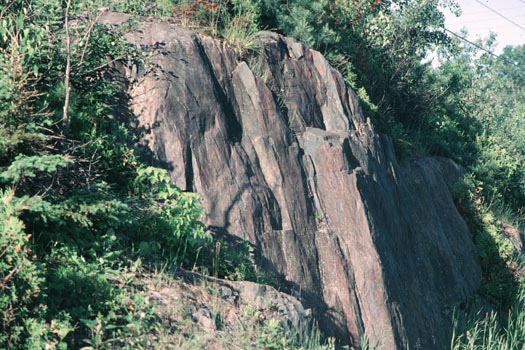
Source: Photograph courtesy of Randy Schaetzl, Professor of Geography -
Michigan State University
Note the locations of Precambrian rocks in Michigan---in the western UP.
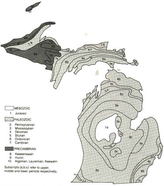
Source: Geology of the Lake Superior Region, LaBerge.
As the thickened, Precambrian crust emerged above sea level, it was stripped by erosion
and the resulting sediments were redeposited in adjacent depressions. As exposed in the
Canadian Shield, the thickened crust consists of multifarious granitic intrusions and
subordinate enclaves of folded and faulted volcanic and sedimentary rocks. The enclaves,
known as "greenstone belts," contain minable concentrations of gold, silver,
copper, zinc and lead. The rocks are called "greenstones" because of the
green hue that the chlorite minerals within impart to the rocks. Greenstones form in
tightly folded and metamorphosed "belts", which in North America often run
east-west. Between the belts are large blocks of folded and metamorphosed gneiss,
and then later, as molten material intruded into these rocks, granites formed amidst the
gneisses and greenstones. The map below shows the abundance of greenstone belts in
Canada, on the Candiamn shield.
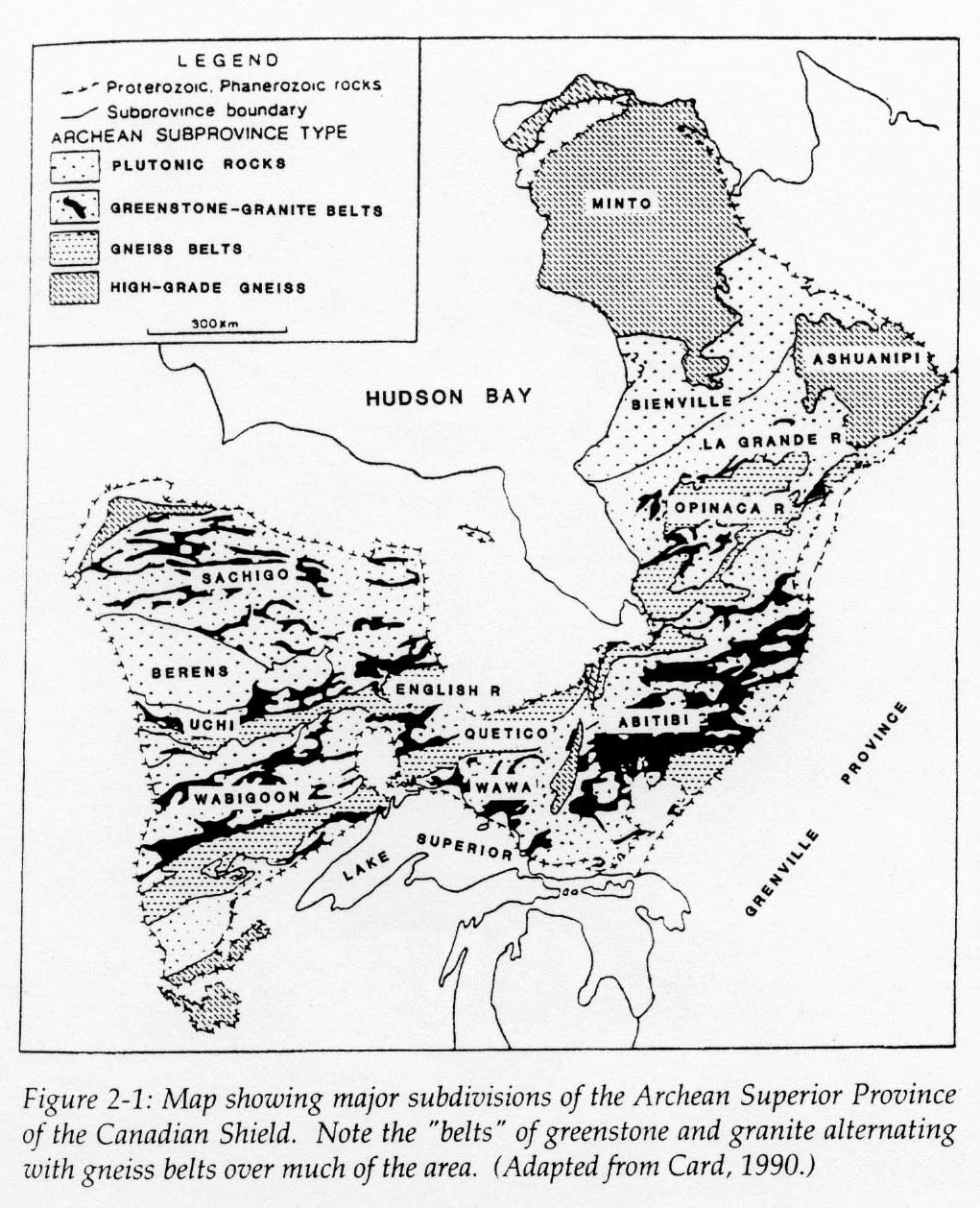
Source: Geology of the Lake Superior Region, LaBerge.
Greenstones are thought to have formed at failed rift zones, as lavas poured out into the tectonically "stretching" crust. Some of these lavas have since been metamorphosed, by compression, to greenstones. After the failure of the rift, the rift then closed again, causing the lavas/greenstones to fold into synclines (the folding created the heat and pressure for the metamorphism). Greenstone belts are often intruded between (younger) granite rocks, as shown below.
A cross-section through a greenstone belt.
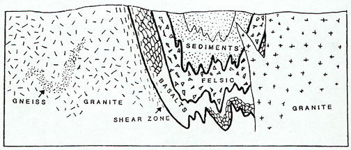
Source: Geology of the Lake Superior Region, LaBerge.
Next, during part of the Precambrian era, a 250 million year-period of
quiet, which we name the Huronian from its record north of Lake Huron, thick
sediments were laid down in a shallow sea trough that covered the Lake Superior region. In
places thick sand was deposited; in other fine muds, and in other places pure lime,
accumulated in the shallow but slowly deepening sea. Over the sand great masses of iron
minerals accumulated, either by chemical action or by the work of iron forming bacteria,
or by both and perhaps other means, until vast thicknesses of sand and iron sediments were
built up. The world’s largest iron deposit was in the
making....in Minnesota, Wisconsin, and Michigan. In that far ago time the
foundations of Michigan’s wealth and the automobile industry were laid in the old
Huronian sediments we now find in the iron ranges of Marquette,
Baraga, Iron, Dickinson, Menominee, and Gogebic counties.
Although one often thinks of copper and iron ore when Precambrian rocks of Michigan are mentioned, other
rocks are also found in the PC formations. For example, there is the green verde antique
and white marbles, graphite, slate, talc, and asbestos of the Huronian rocks. The white
marbles of Dickinson County are too badly shattered for use as a building stone, but are
in use for stucco, small ornamental work, and paint filler. Green marble near Ishpeming
was formerly quarried for use as terrazzo, but it is possible that blocks large enough for
building purposes may be produced. Graphite used for paint was once produced from
graphitic slate quarries east of L’Anse. The fine black slate quarries are on the
northwestern side of the Huron Mountains near Arvon, Baraga County. When the quarries were
in operation the slate was used for roofing shingles. Some of the Ford Museum buildings at
Dearborn are roofed with this slate. Talc and asbestos are in the rocks north of
Ishpeming. Gold has been found in quartz veins of the rocks north
of Ishpeming. The most famous and productive mine was the Ropes Mine, from which over
$625,000 worth of gold was taken. Exploration may reveal more gold-bearing veins. All
these mineral resources await future development and use.
Some of the images and text on this page are from LaBerge's Geology of the Lake Superior Region.
This material has been compiled for educational use only, and may not be reproduced without permission. One copy may be printed for personal use. Please contact Randall Schaetzl (soils@msu.edu) for more information or permissions.