At the close of the Revolutionary War, the country consisted of thirteen states bordering on the eastern seaboard, most of which had rather distinct claims to territory east of the Appalachian Mountains, but also had vague and overlapping claims to large areas between the Appalachian Mountains and the Mississippi River. During the early session of the Continental Congress, the states were prevailed upon to relinquish their claims to most of the territory west of the Appalachians and cede their claims to the federal government. The largest, by far, of these cessions was that of Virginia which (in 1784) turned over to the federal government all the land in the United States west of Pennsylvania, north of the Ohio River and east of the Mississippi River. Some parts of this area were also claimed by Massachusetts and Connecticut, which claims were also relinquished to the government. Thus it may be of interest to note that the present titles to lands in the vicinities of Grand Rapids, Ann Arbor and a large part of Detroit proceed from the charter to Virginia from king James in 1609 and a quit-claim from Massachusetts. The area thus ceded by Virginia became known as the Northwest Territory. This area is of special interest to students of the USPLS System because the subdivision and disposal policies as well as the surveying methods were developed in this region.
The first legislation dealing with the subdivision of these public lands was the Act of May 20, 1795 of the Continental Congress. One of the main points provided in this act was that the rights of the Indian inhabitants should have been extinguished by treaty. As such, no surveys were contemplated in Michigan until after the Treaty of Detroit in 1807 that released the first land in Michigan.
In 1787, Congress passed the Northwest Ordinance. This ordinance set
up a government for the Northwest Territory and outlawed slavery there.
It allowed the region to be divided into separate territories. Once a territory had a
population of 60,000 free citizens, it could petition Congress to become a state. The new
state would then be "on an equal footing with the original states in all respects
whatsoever." This Ordinance was important because it set up a way for new
states to be admitted to the United States. It guaranteed that all states would be treated
equally. Eventually, the Northwest territory was carved into five states: Ohio, Indiana,
Illinois, Michigan, and Wisconsin. As the Indian land titles were being extinguished or
moved farther west, the next step toward the settlement of Michigan’s interior was
the survey of these lands. None of the government lands acquired was
surveyed until after the War of 1812. The government surveyors began their work in
1815 when two men were hired to establish accurately the location of the base line
and the principal meridian. With these standard coordinates
established, other contracts were let to have the townships set off in the eastern part of
the Territory. The instructions to the Land Surveyors were as follows:
"Your field notes are to form a full and perfect history of your operations in the
field. You are to enter in their proper places in the field notes of your survey, a
particular description and the exact location of the following objects:--
1. The length and variation or variations of every line you run.
2. The name and diameter of all bearing trees, with the course and distance of the same
from their respective corners.
3. The name of the material from which you construct mounds, with the course and distance
to the pits.
4. The name, diameter and exact distance to all those trees which your lines intersect.
5. At what distance you enter, and at what distance you leave every river, creek or other
"bottom", prairie, swamp, marsh, grove or windfall, with the course of the same
at both points of intersection.
6. The surface, whether level, rolling, broken or hilly.
7. The soil, whether first, second, or third rate.
8. The several kinds of timber and undergrowth, naming the timber in the order of its
prevalence.
9. All rivers, creeks and smaller streams of water, with their actual or right angled
widths, course, banks, current and bed, at the points where your lines cross.
10. A description of all bottom lands--whether wet or dry, and if subject to inundation,
state to what depth.
11. All springs of water, and whether fresh, saline or mineral, with course and width of
the stream flowing from them.
12. All lakes and ponds, describing their banks and the depth and quality of their water.
13. All coal banks, precipes, caves, sink holes, quarries and ledges with the character
and quality of the same.
14. All water-falls and mill sites.
15. All towns and villages, houses, cabins, fields and sugar camps, factories, furnaces
and other improvements.
16. All metalliferous minerals or ores, and all diggings therefore, with particular
descriptions of both, that may come to your knowledge, whether intersected by your lines
or not.
17. All roads and trails, with the courses they bear .
18. All offsets or calculations by which you obtain the length of such parts of your lines
as cannot be measured with the chain.
19. The precise course and distance of all witness corners from the true corners which
they represent."
That was quite of lot of information! Precisely because of these exhaustive
instructions, the original GLO maps stand today as a resource of inestimable value, for
they provide an immense amount of data on the presettlement status of the lands of the
fledgling United States.
The base line was established east and west along what became the
northern boundaries of the second tier of counties (Wayne, Washtenaw, Jackson, Calhoun,
Kalamazoo, and Van Buren), where the road along these boundaries is still, in some places,
called Base Line Road. Surveying the principal meridian actually began at Fort Defiance, Ohio on September 29, 1815. Deputy Surveyors Benjamin Hough and Alexander Holmes, with at least two other crews, began running a meridian northward, following the western boundary of the territory formed by the 1807 Treaty of Detroit (also the western boundary of the Military District). Meridian Road and Meridian Township
are so named because they are on or near this surveyors’ line. The two lines
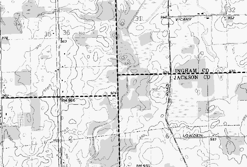
intersect on the Ingham County-Jackson County boundary (see maps below).
All land surveyed in Michigan starts from these points of reference,
with the townships numbered east or west and north or south of these lines. Thus
"T2N, R3W" means the second township north of the baseline and the third west of
the meridian. The sections within each township are numbered from one to thirty-six,
beginning with number one in the northeast corner, continuing westward to number six in
the northwest corner. Directly south of section six is section seven. The numbering
proceeds back and forth across the township to section 36 in the southeast corner. The
maps below illustrate this system, known as the US Public Land Survey (USPLS)
system.
Michigan actually has TWO base lines!!! How can that be?
One of the early contracts for surveys in Michigan Territory was given to Benjamin Hough
on April 28, 1815 for the survey of a true meridian line northward from Fort Defiance,
Ohio. Hough began his work on September 29, 1815. His notes state: "Commence the
meridian, or Indian boundary line at the mouth of the Great Auglaize River and run by the
true meridian due north." Two weeks later, he had progressed 70 miles when he
encountered the Grand River in Section 7, T3S, R1E. A few days later, Hough set the
first Initial Point for the Michigan surveys. He also surveyed the first two miles of the
eastern section of the Base Line across ranges 1 and 2 east. A surveyor named Fletcher
laid out the base line in ranges 3 and 4 east, but his work was grossly inaccurate and had
to be resurveyed. In 1824, Joseph Wampler resurveyed Fletcher’s work and laid out the
four townships cornering on the initial points. His corners are the ones accepted today.
He found it necessary to establish two initial points where the Base Line
intersects the Meridian in order to tie in the survey of the lands already laid out east
of the meridian. These points are 14.18 chains (935.88 feet) apart on the Meridian with
the south line of T1N, R1E. being that distance north of the south line or T. 1 N., R. 1
W.
The figure below shows the two Initial Points – Michigan is the only state to have
such a perturbation in its public land survey.
Source: USGS
By 1820 the crews retained by the government had finished surveying all of the area south
of Flint and east of Jackson, and in the succeeding five years they managed to complete
the southern third of the Lower Peninsula. From 1825 to 1835 there was little surveying
done in Michigan Territory, since most monies for that purpose were spent in Ohio and
Indiana where large numbers of immigrants were settling. The federal funds that Michigan
did mange to receive during this period were mainly channeled into building roads from
Detroit to Fort Gratiot, Saginaw, and Chicago.
In 1836 Michigan's rectangular surveys resumed with full intensity, and
by the end of 1840 nearly all of the Lower Peninsula and part of the eastern Upper
Peninsula had been finished. This rapid progress soon ceased, however, when it was learned
that much of the work had been done carelessly or even faked. To correct these errors,
crews spent the next four seasons in the field resurveying many of the town and section
lines. Once the proper grid network had been run, the task of subdividing the state
continued until the job was finally completed. By 1851, the survey of the entire
state was completed, except for some necessary resurveys of some of the inland lakes,
rivers, and islands.
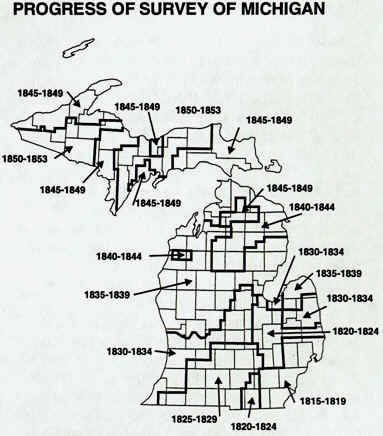
Source: Unknown
The surveys were conducted by individuals under
contract with the United States surveyor general. The surveyor’s task was to run a
line exactly straight in a given direction and to measure that line in units of one mile.
He required two chainmen to measure the line and an axeman to clear the line of brush and
to mark corners. A hardwood stake was driven into the ground at each section corner, with
about a foot length left showing above the ground. The surveyor worked with a compass set
on a tripod. Surveyors had to mark all trees along the line and to maintain careful
records of the crossing of streams, ravines, and hills, the character of the soil and
timber, as well as a description of each township. For this work, they were paid from
$2.00 to $6.50 per mile surveyed. Working eight months a year, the surveyor could earn as
much as $3,000, out of which he had to pay his assistants.
According to the instructions issued to Michigan's federal surveyors,
all men employed in that capacity had to keep a book of field notes for every township and
prepare and accompanying map. The cartographics, to be drawn at a uniform scale of
1:31,680, were required to show certain measurements plus the basic physical and cultural
features in each tract. One copy of the maps so produced was sent to the district U.S.
Surveyor General, and a duplicated sheet was deposited with the state Land Office. The
public could examine either of these sets, and many individuals who did so asked to have
reproductions made. In response to this demand the federal government began to lithograph
the township maps of various states. This projects apparently did not include Michigan
materials until 1894, when most township and private claim plats of the state were
published. Today, the only repository known to have a set of these printed works is the
Bentley Historical Library in Ann Arbor. All of the original surveyors' maps and notes are
kept at the National Archives in Washington, D.C., and the Lands Division, Department of
Natural Resources, in Lansing. A partial collection of the series can be found at the
State Archives, Lansing.
The USPLS system is still the primary means by which the location of parcels of land in
Michigan are described. Note the gas well below, and
its location, described in USPLS terminology on the sign next to it.
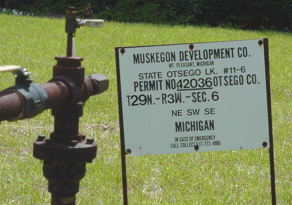
Source: Photograph by Randy Schaetzl, Professor of Geography - Michigan State University
To purchase some replica maps from the original surveyors, go to: project..trygglandoffice.com/maps.html
Some of the text on this page was adapted from Dunbar and May's Michigan A History of the Wolverine State, from the Trygg
land office web page, and from an article by LeRoy Barentt in Michigan
History.
I am grateful to Dr. David Lusch, MSU professor, for his help with this web page.
Some of the text on this page is from: project..ohiokids.org/ohc/history
This material has been compiled for educational use only,
and may not be reproduced without permission. One copy may be printed for
personal use. Please contact Randall Schaetzl (soils@msu.edu)
for more information or permissions.